RETURN TO HANGAR/PRJ-02 // AGRI-SYS
TRL-6 // RELEVANT ENVIRONMENT
[ FIELD TRIALS ACTIVE ]Precision Agriculture & Heavy-Lift Autonomous Robotics

Agricultural Drone Collaboration (Georgia University)

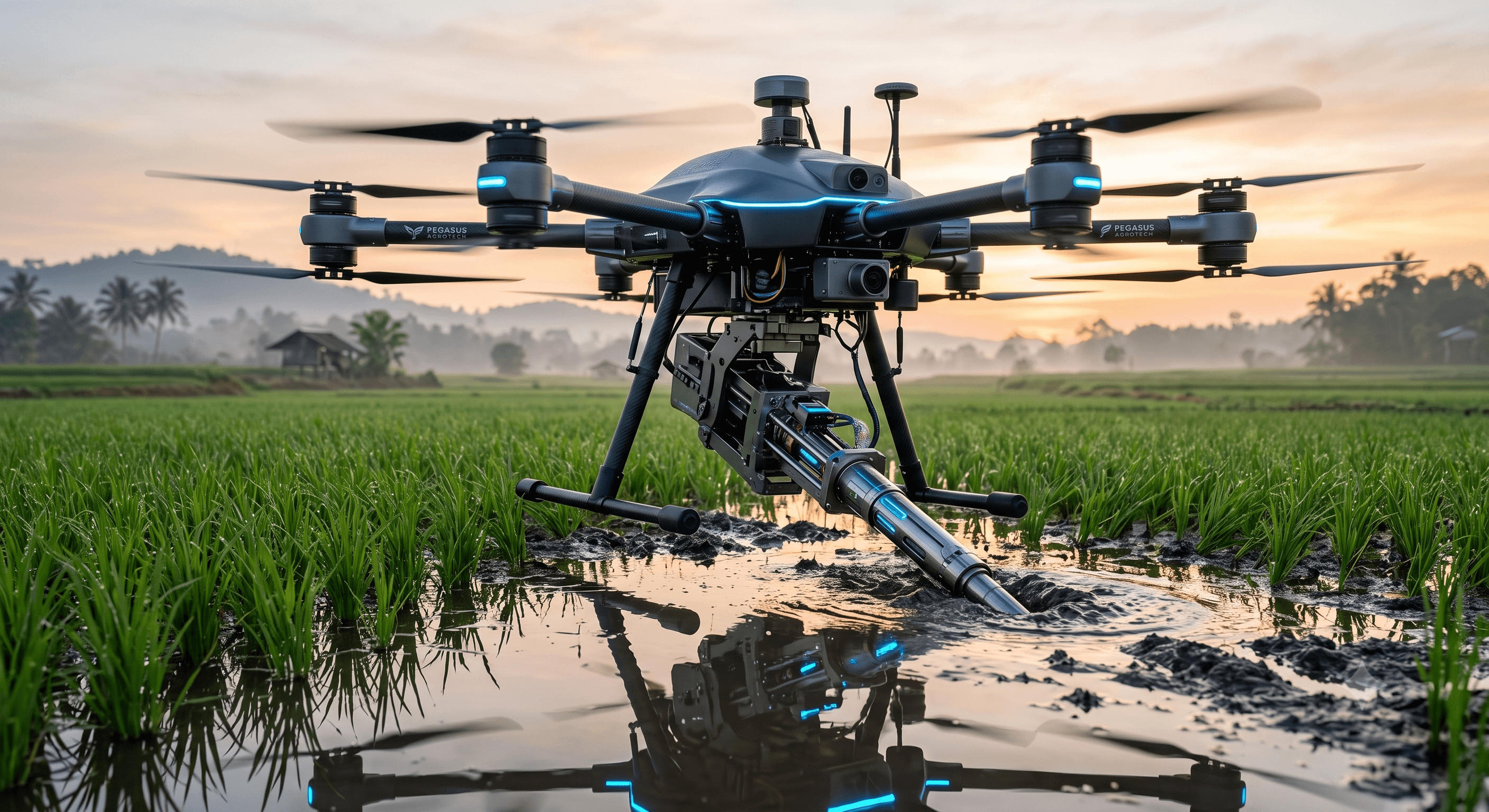
Autonomous Heavy-Lift UAV with Precision Soil Probe Insertion System
PARTNER:Georgia University Agricultural Robotics Lab // Dept. of Space
DIVISION:Payload Mechanics & Precision Geolocation
ROUTER:/agricultural-drone
ACTIVE SUBSYSTEMS:Cube Orange+Holybro H-RTK F9PPX4 AutopilotTarot 650 CarbonQGroundControlLinear ActuatorMultispectral NIR
Agricultural Drone Collaboration (Georgia University)
FEED 01 // TELEMETRY FRAME · PRJ-02 // AGRI-SYS
STATUS: FIELD TRIALS ACTIVE // LIVE
[ 01 -- Telemetry ]

Performance Metrics

Bench-validated telemetry benchmarks, endurance parameters, and operational bounds.

Payload Capacity[ METRIC ]
5.5kg

Heavy-duty CNC linear actuator & sensor probe bay

Positioning Accuracy[ METRIC ]
± 1.5cm

Dual RTK-GNSS rover-base station precision link

Flight Time[ METRIC ]
22min

With full 5kg insertion payload and dual LiPo packs

Insertion Force[ METRIC ]
180N

High-torque stepper drive with active ground resistance sensor

Canopy Cruise Speed[ METRIC ]
8.0m/s

Optimized for high-resolution photogrammetry mapping

Survey Coverage[ METRIC ]
12acres/hr

Autonomous grid path generation with auto soil sampling

[ 03 -- Mission ]

Operational Blueprint

In direct technical collaboration with agricultural robotics researchers from Georgia University, Pegasus UAV Club is engineering an aerial robotic platform capable of autonomously surveying paddy fields and mechanically inserting sensor probes directly into waterlogged soil.

Traditional wheeled and tracked agricultural rovers frequently sink or cause irreversible crop damage in soft paddy soil. This heavy-lift UAV bridges the gap by flying directly over the canopy, hovering with centimeter precision via RTK-GNSS, and driving a vertical insertion rod down to monitor soil moisture, salinity, and nitrogen levels.

The platform integrates a custom CNC-machined carbon payload bay with a high-torque linear actuator, real-time load cell telemetry to detect ground contact resistance, and a multi-spectral camera for simultaneous vegetative index (NDVI) mapping.

PRIMARY ENGINEERING MILESTONES & CAPABILITIES
[ OBJ-01 ]Payload Mechanics & Precision Geolocation

Centimeter RTK Soil Probe Spotting

Fly to pre-computed GIS survey coordinates and hover within ±2cm to align the mechanical insertion guide directly over probe locations.

[ OBJ-02 ]Flight Controls & Autonomy

Ground Reaction Force Balancing

Active thrust compensation during rod insertion: counter-act the 180N upward ground reaction force to maintain rock-solid hover stability.

[ OBJ-03 ]Computer Vision & Perception

Multi-Spectral Vegetation Analytics

Generate orthomosaic NDVI maps during transit to correlate soil sensor readings with crop canopy stress indices.

[ OBJ-04 ]Ground Control & Telemetry

Automated Mission Planning & GCS

Develop custom QGroundControl plugins allowing farmers and agronomists to tap field plots on a tablet for full autonomous sampling.

[ 02 -- Architecture ]

Avionics & Hardware Matrix

Subsystem flight controllers, edge companion compute, perception sensors, and telemetry infrastructure.

01.Autopilot Flight Controller
Cube Orange+ Autopilot
Triple redundant IMU + isolated damping
Configured with PX4 Autopilot for precision altitude hold and payload decoupling.
02.Centimeter Geolocation
Holybro H-RTK F9P Helical GNSS
u-blox ZED-F9P Multi-band RTK Rover
Provides RTK Fixed solution with sub-2cm positioning accuracy over agricultural plots.
03.Payload Deployment Actuator
Custom CNC Linear Drive + Load Cell
NEMA 23 High-Torque Stepper + HX711 Sensor
Monitors penetration force into mud; halts and retracts automatically if obstruction detected.
04.Heavy-Lift Airframe
Tarot 650 Iron Man Carbon Hexacopter
Toray 3K Matte Carbon Weave (650mm wheelbase)
Reinforced folding arm mounts engineered for heavy downward reaction forces.
05.Power Delivery System
Dual 6S 16000mAh Semi-Solid LiPo
High Energy Density 22.2V Architecture
Quick-release battery tray with independent avionics BEC isolation.
06.Multispectral Sensor
MAPIR Survey3W Multispectral NIR
12MP RedEdge + NIR Filter
Geotags crop health imagery directly with RTK coordinate metadata.
[ 04 -- Cadence ]

Flight Logs & Trials

Chronological deployment cadence, laboratory test phases, and verified field outcomes.

[ CADENCE 01 ]
Heavy-Lift Thrust & Payload Balancing
July 2026
PASSED
Demonstrated 24-minute hover with 5.5kg dummy payload at IIST Propulsion Lab.
[ CADENCE 02 ]
RTK-GNSS Accuracy Validation
August 2026
VALIDATED
Stationary hover deviation recorded at 1.4cm radial variance under 12-knot crosswinds.
[ CADENCE 03 ]
Actuator Soil Insertion Trials
August 2026
SUCCESS
Successfully performed 12 automated rod insertions into simulated waterlogged paddy soil.
[ CADENCE 04 ]
Paddy Field Environmental Deployment
Upcoming
ACTIVE
Deploying prototype for live field data collection across partner research plots.
[ NEXT RESEARCH BUILD ]
PRJ-01 // DEF-OPS

Flying Wings: National Defence Hackathon
EXPLORE NEXT SPECS
Flying Wings: National Defence Hackathon